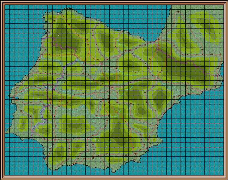
 new campaign map of Spain
Those of you who follow my other blog Paul and Jan in Spain will be aware that we have had visitors from UK
I have however found time to play around with my campaign maps. My current Passau campaign is coming to an end, and the 1813 campaign will move to Spain and Wellington ’s campaign to drive the French out of northern Spain
 road system from AA Road Map of Europe
-->
My first attempt at map making using ProFantasy was a map of Spain Europe , and showed the road system as it is now. For the forthcoming campaign I wanted to recreate the road system of 1813. This has proved very difficult, as I have been unable to find a sufficiently detailed map of the period. So a certain amount of imagination was called for.

I decided that I would start with the regional boundaries and capitals. Only the main regions are shown. I removed the road system from my earlier map, and entered regional borders. I used the same terrain and towns as they were the same in 1813 as they are now.
 main roads in red
I then entered a road system, in red, from Madrid to each regional capital, plus two to Portugal and two to France
 minor roads in yellow
Next I connected each major regional town to its regional capital. I also entered roads using the geographical features such as valleys. These minor roads were in yellow.
These are the only roads which can be used for strategic movement in the campaign. Each square is 20 miles, which is also the daily march rate. Unlike the earlier roads, which allowed access to all parts of the country, these will make possession of a regional capital vital to gain access to the network of minor roads.
The next step will be to produce larger maps showing more detail. This will be done by creating four maps of Spain, all based on this new map. They will cover the top right, top left, bottom right and bottom left. The amount of detail shown will depend on how much can be seen when printed on an A4 sheet of paper.
As with most things, I am not sure how all of this will work out in practice. And I will only find out when I have finished the next stage. No doubt there will be problems, but I hope it will not be necessary to start from scratch again.
No comments:
Post a Comment
I have set the settings for comments to come to me before posting so that I will not miss any